MetaSearch Katalog Client
Einleitung
MetaSearch ist eine QGIS Erweiterung um mit Metadatenkatalogservices zu interagieren und unterstützt den OGC Katalogservice für das Web (CSW) Standard.
MetaSearch stellt eine einfache und intuitiv zu benutzende Benutzerfreundliche Bedienoberfläche um Metadatenkataloge innerhalb von QGIS zu durchsuchen zur Verfügung.
Installation
MetaSearch wurde für QGIS 2.0 und höher entwickelt. Alle Abhängigkeiten sind in MetaSearch Paket enthalten.
Metasearch wird über den QGIS Erweiterungsmanager oder manuell von http://plugins.qgis.org/plugins/MetaSearch installiert.
Bemerkung
Entwickler: Bitte im README für Anleitungen zur installation und Entwicklung von MetaSearch nachschlagen.
Arbeiten mit Metadatenkatalogen in QGIS
CSW (Katalog Services für das Web)
CSW (Catalogue Service for the Web) ist eine OGC (Open Geospatial Consortium) Spezifikation die allgemeine Schnittstellen definiert um Metadaten über Daten, Services und andere potentielle Ressourcen zu entdecken, zu durchsuchen und abzufragen.
Start
Um Metasearch zu starten klicke das MetaSearch Icon oder wähle Web / MetaSearch / MetaSearch mittels des QGIS Hauptmenüs. Der MetaSearch Dialog taucht auf. Das Hauptmenü besteht aus zwei TABS: ‘Services’ und ‘Suche’.
Verwaltung von Katalogservices
Der ‘Services’ TAB erlaubt die Verwaltung aller verfügbaren Katalogservices. MetaSearch stellt eine Standardliste von Katalogservices zur Verfügung die man über den ‘Füge Standard Services hinzu’ Button erreicht.
To all listed Catalogue Service entries, click the dropdown select box.
Um einen Katalog Service hinzuzufügen klicken sie auf ‘Neu’ und geben sie einen Namen und die Adresse des Service ein. Beachten Sie das nur die BasisURL notwendig ist (nicht die Vollständige GetCapabilities URL). Ein Klick auf OK fügt den Service hinzu.
Um einen existierenden Katalogservice zu editieren wählen sie den betreffenden Eintrag aus und klicken die ‘Edit’ Schaltfläche. Ändern Sie Namen und/oder URL und klicken auf OK.
Um einen Katalogservice zu löschen wählen Sie den Eintrag den Sie löschen wollen und klicken auf ‘Löschen’. Eine Sicherheitsabfrage die Sie bestätigen müssen wird erscheinen.
MetaSearch erlaubt Verbindungen in XML Dateien zu speichern. Dies ist nützlich um Einstellungen mit anderen Programmen zu teilen. Unterhalb findet sich ein Beispiel des XML Dateiformats.
<?xml version="1.0" encoding="UTF-8"?>
<qgsCSWConnections version="1.0">
    <csw name="Data.gov CSW" url="http://catalog.data.gov/csw-all"/>
    <csw name="Geonorge - National CSW service for Norway" url="http://www.geonorge.no/geonetwork/srv/eng/csw"/>
    <csw name="Geoportale Nazionale - Servizio di ricerca Italiano" url="http://www.pcn.minambiente.it/geoportal/csw"/>
    <csw name="LINZ Data Service" url="http://data.linz.govt.nz/feeds/csw"/>
    <csw name="Nationaal Georegister (Nederland)" url="http://www.nationaalgeoregister.nl/geonetwork/srv/eng/csw"/>
    <csw name="RNDT - Repertorio Nazionale dei Dati Territoriali - Servizio di ricerca" url="http://www.rndt.gov.it/RNDT/CSW"/>
    <csw name="UK Location Catalogue Publishing Service" url="http://csw.data.gov.uk/geonetwork/srv/en/csw"/>
    <csw name="UNEP/GRID-Geneva Metadata Catalog" url="http://metadata.grid.unep.ch:8080/geonetwork/srv/eng/csw"/>
</qgsCSWConnections>
To load a list of entries, click the ‘Load’ button. A new window will appear; click the ‘Browse’ button and navigate to the XML file of entries you wish to load and click ‘Open’. The list of entries will be displayed. Select the entries you wish to add from the list and click ‘Load’.
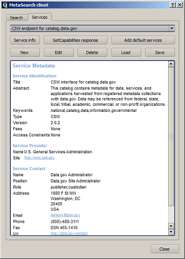
The ‘Service info’ button displays information about the selected Catalogue Service such as service identification, service provider and contact information. If you would like to view the raw XML response, click the ‘GetCapabilities response’ button. A separate window will open displaying Capabilities XML.
Searching Catalogue Services
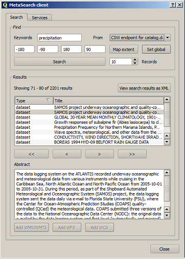
The ‘Search’ tab allows the user to query Catalogue Services for data and services, set various search parameters and view results.
The following search parameters are available:
- Keywords: free text search keywords
- From: the Catalogue Service to perform the query against
- Bounding box: the spatial area of interest to filter on. The default bounding box is the map view / canvas. Click ‘Set global’ to do a global search, or enter custom values as desired
- Records: the number of records to return when searching. Default is 10 records
Clicking the ‘Search’ button will search the selected Metadata Catalogue. Search results are displayed in a list and are sortable by clicking on the column title. You can navigate through search results with the directional buttons below the search results. Clicking the ‘View search results as XML’ button opens a window with the service response in raw XML format.
Clicking a result will show the record’s abstract in the ‘Abstract’ window and provides the following options:
- if the metadata record has an associated bounding box, a footprint of the bounding box will be displayed on the map
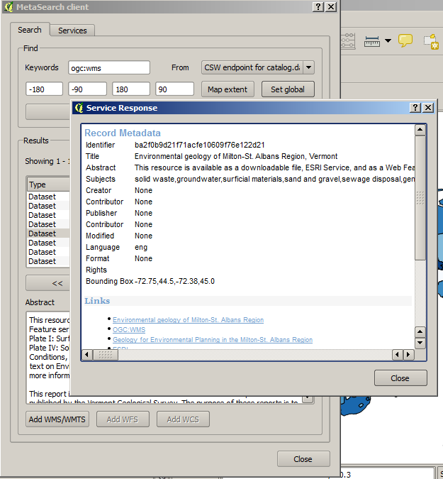
- double-clicking the record displays the record metadata with any associated access links. Clicking the links opens the link in the user’s web browser
- if the record is an OGC web service (WMS/WMTS, WFS, WCS), the appropriate ‘Add to WMS/WMTS|WFS|WCS’ buttons will be enabled for the user to add to QGIS. When clicking this button, MetaSearch will verify if this is a valid OWS. The OWS will then be added to the appropriate QGIS connection list, and the appropriate WMS/WMTS|WFS|WCS connection dialogue will then appear
Settings
You can fine tune MetaSearch with the following settings:
- Results paging: when searching metadata catalogues, the number of results to show per page
- Timeout: when searching metadata catalogues, the number of seconds for blocking connection attempt. Default value is 10
Support
- Mailing list: http://lists.osgeo.org/listinfo/qgis-user
- IRC: irc://irc.freenode.net/qgis
- Issue tracker: https://github.com/geopython/MetaSearch/issues
- Source code: https://github.com/geopython/MetaSearch
- Wiki: https://github.com/geopython/MetaSearch/wiki